

Whatever your reason is for walking the Camino, you will be beguiled by its landscape and the feeling of adventure. Once you have started you are likely to get addicted to the daily rhythm of this wonderful journey.
As we have already revised the 1st stage of Camino Frances in the last post, we are going to continue with this route and we are going to review the 2nd stage of Camino Frances from Logroño to Burgos. This second stage is shorter and relatively easier compared to the first stage. Pilgrims can walk this stage in 6 days.
Day 1. Logroño
After crossing the majestic river Ebro, pilgrims will reach the city center. Logroño is the perfect place to enjoy good wine and tapas. The Rioja is Spain’s most celebrated wine region. In some areas of the country, its name actually serves as a synonym for wine: the way to request a glass of generic red is to shout “un Rioja!” at the barman. Spaniards well know that eating tapas in Logroño isn’t the cutting-edge gastronomic experience it is in San Sebastián, or the traditional one it is in Seville, but it is infinitely more fun. Still, most of the people you’ll see there are locals, whether part of the wine industry or not. They’re heading out after work to spend time with friends, eat a few snacks, and drink a few glasses of tinto or Rosado.
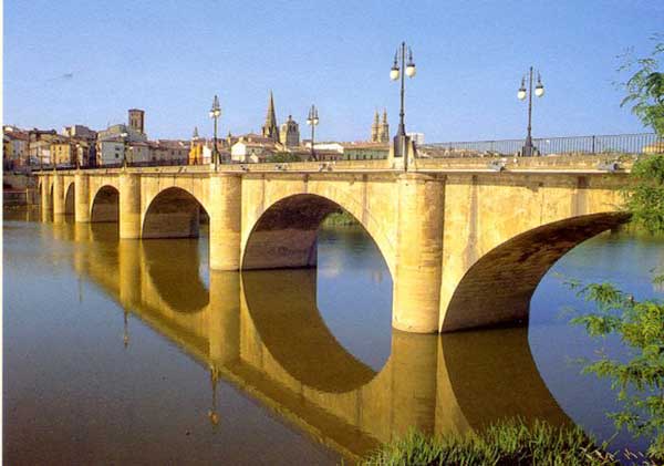
Logroño was an old settlement, first of the Romans, under the name of Vareia, a commercial port, and then of the Celts. You shouldn´t miss visiting El Puente de Piedra, which is one of the four bridges on the Ebro River in Logroño. It is also called San Juan de Ortega Bridge and the current construction dates from 1884, after the old bridge collapsed in 1871. It is one of the symbols of the city, it appears on its coat of arms and it is the entrance to the city on the Way of Saint James.
And Cathedral de Santa María de la Redonda is also very interesting. The Cathedral of Logroño was built over a Romanesque primitive temple from the XII Century. Its name comes from its circular floor.
Day 2. Nájera
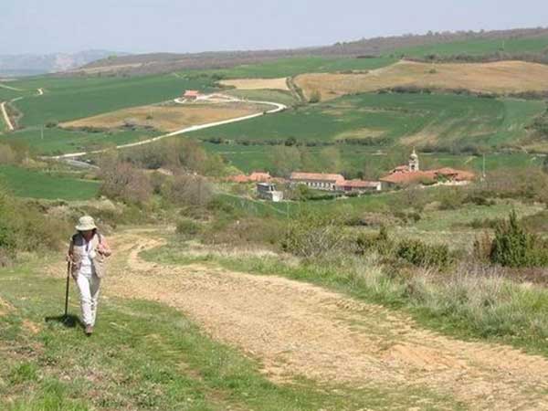
Starting with a long stage: 30 kms (18,5 miles). The good information: the terrain is flat. You will discern Nájera on the horizon 2 hours before reaching the town. This simple yet extensive-stage, with moderate slopes, provides a visual reward to hikers as they advance among vineyards and wide valleys and discover historical towns on this Jacobean route, such as Navarrete and at the end Nájera. The only downside to this pleasant route is that in summer the debilitating high temperatures, a problem that can only be fought in the recreational areas that mark the journey such as Grajera Park. Pilgrims will find no problem here to satisfy their hunger or thirst in one of the towns through which the road passes, and also in the small towns on route that provide services for walkers. At the top of Grajera, walkers are greeted with a great view over Logroño. The hiker continues parallel to a metal fence, which pilgrims have covered with a number of wooden crosses (a tradition extending along the entire pilgrimage route). The traveller then heads to Navarrete though, before arriving, goes through one of the many wineries in the area and passes the ruins of the hospital of San Juan of Acre, founded around 1185 as a shelter and aid for pilgrims. Archaeological excavations conducted in 1990 allowed them to locate the main walls of the old hospital, which had a large church with a Latin cross and a round tower with a spiral staircase. Navarrete(Nájera 15.4 kilometres), a town famed for its pottery and Jacobean past. The road continues through stone ridden areas, sometimes rocky, and flanked by curious mounds of pebbles. At a steady pace, but without much effort, the route climbs gradually to Alto de San Antón (located 670 meters and 7.1 kilometres from Nájera), a hill with panoramic views, allowing hikers a glimpse of the clay landscape, the extensive valley of Najerilla and the still distant Nájera.
Day 3 Santo Domingo de la Calzada
This part is easier – only 22 km (13 miles). Santo Domingo de la Calzada is famous due to the rooster that sung before roasted. There are many versions of the legend but at the end the rooster always proves the innocence of the poor pilgrim accused of the theft. Every sign in the town will remind you of this legend. In this easy and achievable stage with moderate slopes (the highest being 255 meters), the walker will travel firstly along agricultural tracks, and through fields of grain and vines. Finding shadows in the summer is the only difficulty of this route. From the ancient and nice Azofra, and as a highly recommended visit, the pilgrims can deviate from the ancient path and visit San Millán de la Cogolla, birthplace of the Spanish language, from which they will return via another path to join the pilgrimage route a few kilometres later. Despite the extra kilometres, almost 30, this trip will not disappoint the hikers.The final stretch of the day is on a long wavy path, with just one final goal, Santo Domingo de la Calzada, one of the great icons of the Camino.
Day 4. Belorado
In the daily and unceasing advance involved in this French pilgrim route, todays journey will say goodbye to La Rioja to face with strength the long hard journey to the spacious Castilla. This journey does not involve many kilometres for hikers to catch their breath or to enjoy the walk itself. This easy journey requires a certain amount of momentum, travelling west and crossing a number of locations that remain for the most part, model villages on this Jacobean route. Passing through the main streets of successive enclaves, where hikers will find no problem in purchasing supplies. The walkers can recall the hospitals that during the middle Ages provided shelter to the pilgrims and that, in some cases, still retains their structure. They can also stay in hostels and towns that have captivated illustrious pilgrims, such as Paulo Coelho, author of The Pilgrim of Compostela and sponsor of a hostel in Viloria de la Rioja. Diverse examples of Romanesque art, like the baptism basin Redecilla del Camino, strengthen the interest in this rapid passage. The only disadvantage of this step is the number of junctions with the N-120 some are quite dangerous due to poor visibility.
Day 5. Juan de Ortega
This stage, described as mid-mountain, is divided into two different parts. The first, which passes through small enclaves with services, serving as a point of contact and training for the subsequent ascent that begins in Villafranca de Montes de Oca, with hard slopes, although not very long. In this town pilgrims are advised to purchase supplies, as they will face more than 12 kilometers without services and very few drinking water fountains. The old and formally feared Montes de Oca guides the walkers along dirt tracks, a solitary journey until reaching San Juan de Ortega, a small Jacobean enclave with a hostel and a Romanesque church. The gravel path gives way to a wide forest track surrounded by a forest of pine and oak trees through which, they reach a gentle descent to San Juan de Ortega .
Day 6. Burgos
On the way out of San Juan de Ortega, after a short stretch on asphalt there is a crossroads with many signs from which large wooden cross stands out. To reach Agés pilgrims must enter a track that passes through a pine forest rich in mushrooms. The collection of these fungi is regulated, and only allows those that have a local license to pick them.With the disappearance of pines they will discover magnificent views over the fields of Burgos. Walkers should not get lost from here. But just in case, the few trees found at the foot of the Camino are light up with yellow arrows that lead the way.
The exit from Agés is via the main road that passes through the town itself. Leaving on the left hand side a small picnic area with a couple of swings, the point at which the town of Atapuerca can be seen, the next destination. After two and a half kilometres on the local road (well paved and with few vehicles, but no shelter), several posters (one of them, for the visitor reception centre) inform pilgrims that they are about to enter Atapuerca. The paleontological site of Atapuerca is undoubtedly one of the most important and famous in the world, situated some distance from the village itself. The Camino of Santiago does pass directly through the caves of Atapuerca (for this walkers need to take another variant).Leaving Atapuerca can be confusing, as some signals are not as clear as they should be.
Atop the mountain, La Cruz de Matogrande dominates a large esplanade. Proceed straight. Leaving behind a representation of concentric circles of stones. On beginning the descent walkers can enjoy the view of Burgos.

We will see each other in Burgos next time.
Buen Camino, amigos!
Anxo Saco.
Comments